LightPlan is the Shadowmap alternative made for photographers. Shadowmap is a 3D shadow and solar tool built for homes, real estate and solar panels. LightPlan has a Shadow Map too, and adds everything a photographer plans around: the sun and the moon, golden and blue hour, an eye-level view from where you'll stand, AR on the real sky, the weather and the best Milky Way nights. All on one easy screen, free to start.
Why photographers choose LightPlan over Shadowmap
The moon, not just the sun
Moonrise and moonset lines and times, a Moon Calendar with phases and eclipses, and moon tracking on the map. Shadowmap's site and listings don't mention the moon.
Golden and blue hour, timed
Both windows timed by the sun's angle, shown as a chip on the map and as bands on the timeline. Shadowmap lists no golden or blue hour window.
Google's photorealistic 3D, free
Plan on Google's photorealistic buildings and trees in LightPlan's free version. In Shadowmap, Google 3D buildings come with the Studio plan ($59.99 a month).
AR on the real sky
AR Sky View, free, draws the sun's and moon's paths across the real sky on location. Shadowmap doesn't list AR.
Milky Way nights, ranked
A planner that scores every night on darkness, core height and moonlight, and ranks the next 30 at your spot.
Clouds on the map
Cloud cover and rain drawn on the map and tied to the timeline, so you know whether the light will reach your scene at all.
Easy from the first minute
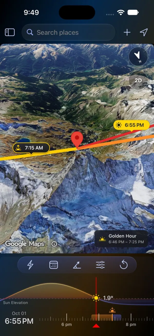
LightPlan is built so you can plan a shot without a tutorial. Your first plan takes three steps:
- Put the marker on your subject. Search for a place, or tap the map.
- Pick the day and time. Tap Date, then drag the timeline to the hour.
- Read the light. The lines point to the sun and moon, and a chip on the map says when it's golden or blue hour.
There are no panels to decode before you start. Times are always in the place's own time zone, the timeline is coloured like the light, and Product Tour replays the tips on the real controls whenever you want a refresher.
Shadowmap is organised around property and solar analysis, with its tools spread across four plans (Free, Explorer, Home and Studio). LightPlan is organised around one photographer's question, where and when the light will be, and answers it on one screen.
Shadow Map: see where the light falls
Drag the timeline and every building, tree and hillside casts its real shadow at that moment. Here is San Francisco City Hall on the same day, six and a half hours apart:
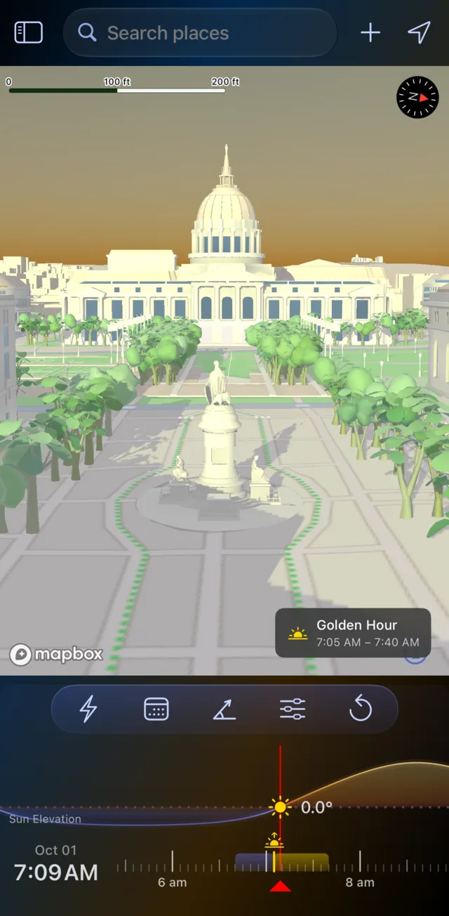
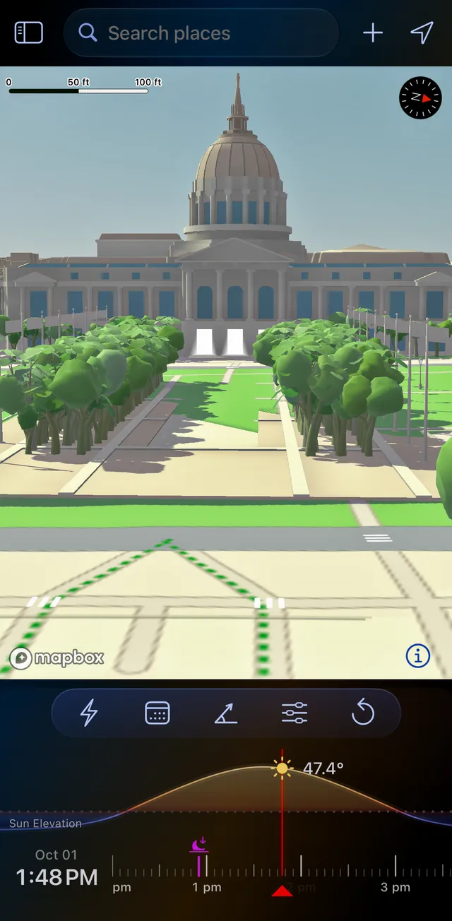
San Francisco City Hall, 1 October 2026.
- Find open shade for a portrait session, or the hour a facade is evenly lit with no hard shadows across it.
- Measure a shadow. A shadow object at the marker stands in for a person, a tree or a building; set its height and width, and LightPlan shows its Shadow Length and Shadow Ratio. At 1:48 PM here, a 6 ft person casts a shadow about 5.5 ft long.
- On iPhone Duo: Opened out and turned sideways, Split View shows the Shadow Map beside the main map.
- Beyond photography: when a garden, terrace or street gets sun, or where a new building's shadow will fall.
LightPlan's Shadow Map draws on Mapbox's 3D buildings and trees, with the terrain. Shadowmap goes deeper on shadows and sunlight themselves: it measures sun hours and annual solar exposure on roofs and facades (Studio), lets you edit buildings and trees and place objects, and imports your own 3D models (Studio). For a photographer, LightPlan's shadows sit alongside everything else you need for the shot. Shadow Map is part of LightPlan Pro; open it from Quick Actions or the menu.
Shadows are half the picture: the moon through the Palace of Fine Arts
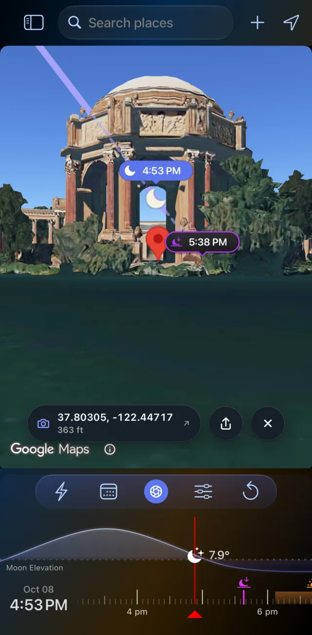
A shadow tool tells you where the sun's light falls. A photographer also needs to know where the moon will be, when the light turns golden, and what the frame will look like from the spot where you'll set up your tripod. Here's a crescent moon framed in the rotunda of San Francisco's Palace of Fine Arts, planned in LightPlan:
- Put the marker on the rotunda, switch to Photorealistic 3D, tap the eye, and tap where you'll stand across the lagoon.
- Set Track to Moon, step through the dates and drag the timeline until the moon sits in the arch.
- Set the Lens to your focal length, then send the plan as a link that opens in LightPlan or on the web.
Checked with an independent ephemeris: at 4:53 PM on 8 October 2026 the moon is 7.9° above the horizon at an azimuth of 263°, a 3% crescent, lining up with the rotunda, which lies at 257° from where you stand.
Shadowmap's site and listings don't mention the moon, so this is a shot you'd plan in LightPlan.
Golden hour, blue hour and the sun's lines
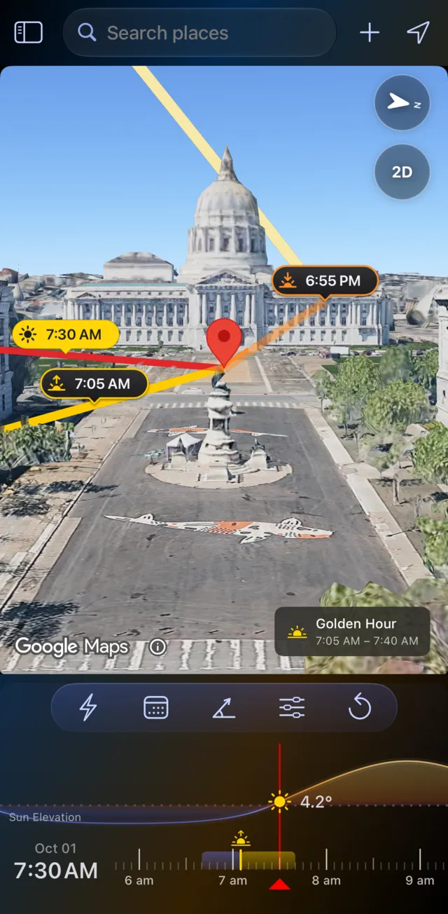
The same City Hall, on the same morning as the Shadow Map captures above, now on LightPlan's main map. Lines point to sunrise, sunset and the sun at the time you pick, each with its time, and a chip says it's golden hour, 7:05 to 7:40 AM.
- Golden hour runs while the sun is between 6° above and 4° below the horizon; blue hour from 4° to 6° below. Both are timed by the sun's height, so they stretch and shrink with the season and the place.
- The timeline is coloured like the light, with gold and blue bands for each window.
- The moon gets its own lines and times. Set Track to Moon and everything follows it.
Read more in our golden hour guide, including the colour temperature of the light at each sun angle.
AR on the real sky, free
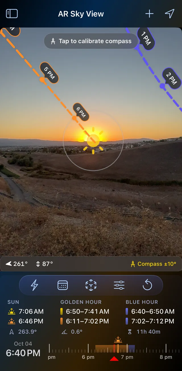
On location, hold up your phone: the sun's path is drawn across the real sky with a time at every hour, the moon's in blue, and the day's sunrise, sunset, golden hour and blue hour sit underneath for exactly where you're standing.
- Arrows point the way to a sun or moon that's off screen.
- Compass accuracy is always shown (±10° here); calibrate against the real sun or moon in the crosshair when it drifts.
- Drag the timeline to see any other hour.
- With Pro, the Milky Way core's path across tonight's sky.
AR Sky View is free in LightPlan on iPhone, iPad and Android. Shadowmap's site and listings don't mention AR.
The Milky Way, scored night by night
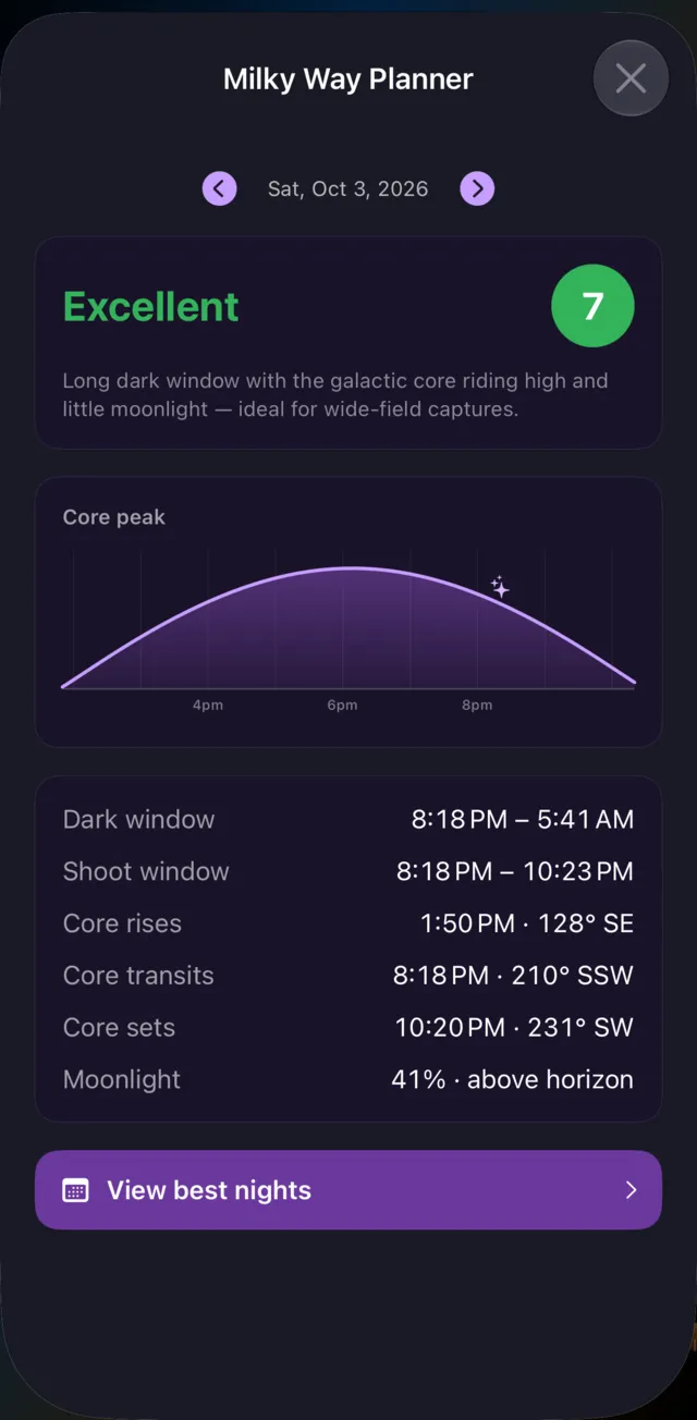
A great Milky Way night needs three things at once: real darkness, the galactic core above the horizon, and the moon out of the way. LightPlan's planner finds where they overlap and tells you, in plain numbers:
- Dark window: when the sun is at least 18° below the horizon.
- Shoot window: dark, with the core up, and with the moon down if it's half lit or more.
- The core: when it rises, peaks and sets, and which way to face.
- A score from how long it's dark, how high the core climbs and how little moonlight there is.
Best Milky Way Nights ranks the next 30 nights at your location (the top 3 are free), and an alert can warn you one to three days before a great night at any saved spot. Shadowmap's site and listings don't mention the Milky Way.
More that sets LightPlan apart
- Observer View: stand where you'll shoot, at eye level or up to 1000 m for a balcony or a drone, with a 14–600 mm lens and a line of sight that turns red where terrain blocks the view (Pro).
- A native Mac app. Shadowmap runs on Mac as its iPad app, on Apple silicon.
- Alerts before sunrise, sunset, golden hour, the moon and great Milky Way nights, and Siri on Apple devices: "When is golden hour in LightPlan".
- Plan links that open in LightPlan, or on a 3D map on the web with the day's light windows and directions.
Feature by feature
| LightPlan 3.0 | Shadowmap | |
|---|---|---|
| Built for | Photographers planning light | Homes, real estate, architecture and solar |
| Ease of use | Everything on one screen; first plan in three steps | Tools spread across Free, Explorer, Home and Studio plans |
| Moon position, rise and set | Yes | Not listed |
| Golden hour and blue hour windows | Yes — timed by sun angle | Not listed |
| Milky Way planning | Yes — scored nights, 30-night ranking | Not listed |
| AR view | Yes — AR Sky View, free | Not listed |
| Google photorealistic 3D | Yes — free | Studio plan ($59.99/month) |
| Eye-level view with your focal length | Yes — Observer View, 14–600 mm (Pro) | First-person view on Explorer and above |
| Cloud and rain on the map | Yes — Pro | 14-day weather and UV forecast on Home |
| Alerts before the light | Yes | Not listed |
| Mac | Yes — native app | iPad app on Apple silicon Macs |
| Shadows from buildings, trees and terrain | Yes — Shadow Map (Pro) | Yes — today free; any date on Explorer ($29.99/year) |
| Web app in a browser | Plan links open on the web | Yes |
| Sun hours and solar analysis | No | Yes — Studio |
| Edit buildings, import 3D models | No | Yes — editing on all plans; model import on Studio |
Based on each app's website and store listings as of 14 October 2026; prices are US prices. Apps change, so check the current listing before you buy. "Shadowmap" is a trademark of its owner; LightPlan is independent and not affiliated with, endorsed by or sponsored by it.
When Shadowmap still makes sense
To be fair: Shadowmap is a specialist in shadows and sunlight for property. If you're choosing a home, planning a garden or sizing solar panels, it measures sun hours and annual solar exposure on roofs and facades (Studio), lets you edit buildings and trees, imports your own 3D models, and runs in a web browser. Its free plan shows today's shadows without an account. For planning photographs, though, you'll want the sun and moon, the light and the sky as well, and that's what LightPlan is for.
Frequently asked questions
What's the best Shadowmap alternative for photographers?
LightPlan. It has its own Shadow Map for real shadows from buildings, trees and terrain, and adds what photographers plan around: the sun and moon with rise and set times, golden and blue hour, Observer View at eye level with your focal length, AR Sky View on the real sky, cloud and rain forecasts, and a scored Milky Way planner. It's free to start on iPhone, iPad, Mac and Android.
Is Shadowmap free?
Partly. Shadowmap's free plan shows the sun path and shadows on 3D buildings, terrain and trees, but only for the current day. Choosing any other date, and the first-person view, needs the Explorer plan ($29.99 a year on the App Store); weather and higher-quality buildings need Home ($9.99 a month); solar analytics and Google 3D buildings need Studio ($59.99 a month).
Is LightPlan's Shadow Map free?
Shadow Map is part of LightPlan Pro ($2.99 a month or $19.99 a year in the US), which starts with a free trial. LightPlan's free version covers the sun and moon lines and times, golden and blue hour, Photorealistic 3D, Terrain and 2D maps, AR Sky View, the Moon Calendar and the Milky Way Planner, for today and the next 2 days.
Does Shadowmap show the moon?
Shadowmap's website and store listings don't mention the moon, blue hour, the Milky Way or AR. LightPlan tracks the moon as well as the sun, with moonrise and moonset lines and times, a Moon Calendar with phases and eclipses, and Observer View for lining the moon up behind a peak or a building.
What does LightPlan do that Shadowmap doesn't?
For photographers: moon tracking and the Moon Calendar, golden and blue hour timed by the sun's angle, Observer View on Google's photorealistic 3D, AR Sky View, a Milky Way planner that scores and ranks nights, cloud and rain on the map, alerts before the light, and a native Mac app. Google's photorealistic 3D map is free in LightPlan; in Shadowmap, Google 3D buildings come with the Studio plan.
Is Shadowmap better for real estate or solar panels?
Often, yes. Shadowmap's Studio plan measures annual sunlight and solar irradiation on roofs and facades, imports your own 3D models, and lets you edit buildings and trees; its Home plan targets home buyers and gardeners. LightPlan is built for photographers planning light, and its Shadow Map is for seeing where shadows fall at a given time.
Is LightPlan free?
LightPlan is free to use every day with no account. The free version covers today and the next 2 days: sun and moon lines and times, golden and blue hour, Photorealistic 3D, Terrain and 2D maps, AR Sky View, the 3D Compass, the Moon Calendar, the Milky Way Planner with the 3 best nights ahead, 5 saved locations, sunrise and sunset alerts, and plan links. LightPlan Pro ($2.99 a month or $19.99 a year in the US, with a free trial) adds any date, unlimited locations, Observer View, Shadow Map, weather layers, the full Milky Way forecast, every alert and widgets.
Try LightPlan free
The sun, the moon, the light and the shadows, planned in 3D. Free to start on iPhone, iPad, Mac and Android.