The basics
The screen, the lines on the map, time and the light.
Start here
The main screen
Everything starts at the red marker. Put it on the spot you want to photograph, pick a time, and the map shows where the sun and moon will be.
- 1MenuSwitch between Sun & Moon, AR Sky View and Shadow Map, and open the Milky Way Planner, Moon Calendar, 3D Compass, Alerts and Help.
- 2SearchFind a place by name, or type its coordinates.
- 3AddSave the marker's spot, with the current view, as a location.
- 4Saved LocationsYour places. Current Location, at the top, takes you to where you are.
- 5CompassTurns the map back to north. At your current location, it turns the map as you turn (heading-up).
- 62D / 3DFlips between a flat map and the 3D map.
- 7Observer View PROLook from where you'll stand, at eye level.
- 8The markerYour subject. Tap the map to move it.
- 9Sun and moon linesWhere they rise and set, and where they are at the selected time.
- 10Light chipShows during golden hour and blue hour. Tap it for the times and the colour of the light.
- 11ToolbarQuick Actions, Date, Camera, Settings and Reset (below).
- 12TimelineThe sun's height through the day. Drag it to change the time.
- 13Selected timeThe red playhead. Its date and time sit on the left, in the location's own time zone.
The toolbar
- Quick ActionsSwitch views, track the sun or the moon, and share a plan.
- DatePick the day you're planning.
- CameraTurn, tilt and zoom the map, or pick a preset view. In Observer View it becomes Lens.
- SettingsThe map, the timeline's chart, labels and golden hour on the map.
- ResetBack to now, with the marker in the middle.
Move around the map
MacScroll or pinch on the trackpad to zoom, and click to move the marker. See LightPlan on Mac.
The map
Read the lines
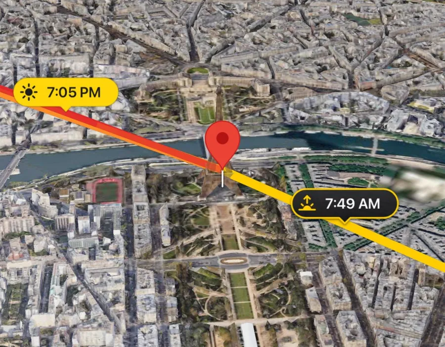
Each line starts at the marker and points the way you'd face to see the sun or moon. The red line follows the time you pick. Try it:
- SunriseWhere the sun comes up.
- SunsetWhere the sun goes down.
- MoonriseWhere the moon comes up.
- MoonsetWhere the moon goes down.
- The selected timeToward the sun or moon you're tracking. It turns faint while that body is below the horizon.
Also on the map
- Tracking pathThe whole day's path, from rise to set. In 3D it climbs as high as the sun or moon does.
- Golden Hour On MapFans that cover the sun's directions during the morning and evening golden hour. Turn them on in Settings.
In Settings, Rise & Set Labels shows or hides the times on the lines, and Tracking Path Distance sets how far out the path is drawn (Auto grows it as you zoom out, up to 500 km).
Time
Move through the day
The timeline under the map is a clock you can drag. The lines, the light and the shadows all follow it.
- 1The day arcThe sun's height through the day, coloured like the light: gold by day, rose at sunset, violet and blue into the night.
- 2The horizonAbove the dashed line the sun is up; below it, it's down.
- 3Rise and setSunrise and sunset, marked where the arc crosses the horizon.
- 4Golden and blue hourGold and blue bands under the scale mark each window.
- 5PlayheadThe selected time. The map shows this moment.
- 6ElevationHow high the sun or moon stands at that time, in degrees.
- 7Date and timeAlways in the location's own time zone, wherever you are.
Timeline gestures
Rise & Set: the day in numbers
Swipe the timeline up or down for the day's times instead of the chart. You can choose which one shows under Settings › Infographic.
Sun
19:40–20:39
20:39–20:51
Moon
Pick another day
Tap Date in the toolbar and choose a day. The map, lines and times all move to it. Free plans cover today and the next two days; PRO opens every date, years ahead or back.
The light
Golden hour and blue hour
LightPlan times the light by how high the sun is, not by the clock. That's why the windows stretch and shrink with the season and the place.
An evening, start to finish
- Day
- Golden hour
- Sunset
- Blue hour
- Twilight, then night
- The light chipWhile the selected time is in golden or blue hour, a chip on the map says so. Tap it for the morning and evening windows and the colour of the light.
- Golden Hour On MapTurn it on in Settings to see which directions the golden light comes from.
- The terrain glows tooThe Terrain map takes on the light of the hour: warm at golden hour, cool at blue hour, dim at night.
See the shot
Choose a map, frame it, and stand where you'll shoot.
Maps
Choose your map
Two maps, each flat or in 3D. Pick the one that suits the scene; the sun and moon follow you between them.
Photorealistic 3D
Google's 3D city and landscape: real buildings, streets and trees.Best for cities, architecture and people.
Satellite 2D
A flat, top-down satellite view. Quick to read, and where the weather layers live.Best for scouting and checking clouds and rain.
Terrain 3D
A topographic map on real 3D relief, lit by the hour, with the moon in its sky and peaks labelled.Best for mountains, valleys and open land.
Terrain 2D
The same topographic map, flat. Weather layers work here too.Best for reading the land at a glance.
- Settings › MapChoose Satellite or Terrain.
- 2D / 3DTap the button on the map to flip between flat and 3D.
AndroidIn Settings, Map lists Photorealistic 3D, Satellite 2D and Terrain 3D; the 2D/3D button flips between them.
Heading-up: the map turns as you turn
The view
Frame the view
The map's camera circles the marker. Tap Camera in the toolbar to place it exactly, or pick a preset.
- 1Camera AngleWhich way the camera faces, all the way round (0–360°).
- 2Camera Tilt0° looks straight down; 90° looks out level with the ground.
- 3RangeHow far the camera is from the marker, from 75 m to 400 km.
- 4AltitudeRaises the point the camera looks at above the ground, to frame a summit or a rooftop.
Presets, in one tap
The camera sheet has three tabs: Angle, Distance and Presets. On a flat 2D map you only need angle and range, so it shows just those.
- CenterBrings the marker back to the middle without changing the range.
- Save As PresetKeeps the current view in one of the six preset slots, replacing what was there.
- ResetIn the toolbar: back to now and the marker, and any odd camera values fixed.
New in 3.0
Observer View PRO
Stand where you'll shoot. Drop a pin, and LightPlan puts you there at eye level to watch the sun or moon cross the real skyline.
- 1Observer pinThe blue pin: where you'll stand.
- 2Eye HeightYou see from standing height. Raise it for a tripod on a wall, a balcony or a drone.
- 3Line of sightA dashed line from you to the marker. It turns red where the land blocks the view.
- 4MarkerThe red marker is your subject. The view opens facing it.
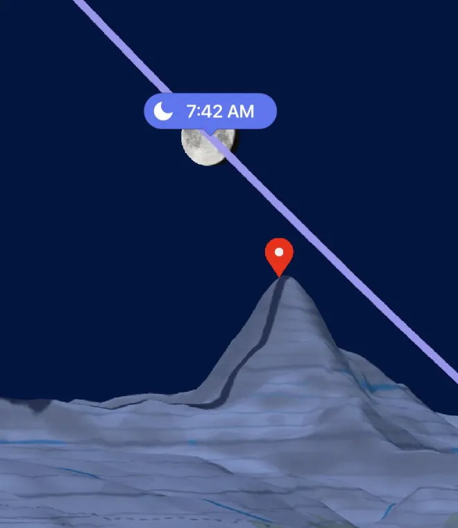
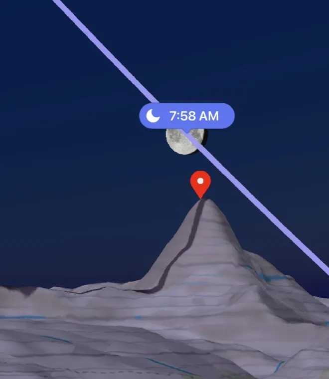
- 5Sky pathThe day's path of the sun or moon, drawn far away so ridges hide it just as they will on the day.
- 6Your lensWhat fits in the frame. Pinch, or set Focal Length, to zoom.
- Tap the eyeOn the Photorealistic 3D or Terrain 3D map.
- Tap where you'll standThe pin drops and you fly in to eye level.
- Look aroundDrag to look, pinch to zoom the lens, and move through time on the timeline.
- Tap the eye to leaveBack to the map, with your pin kept for next time.
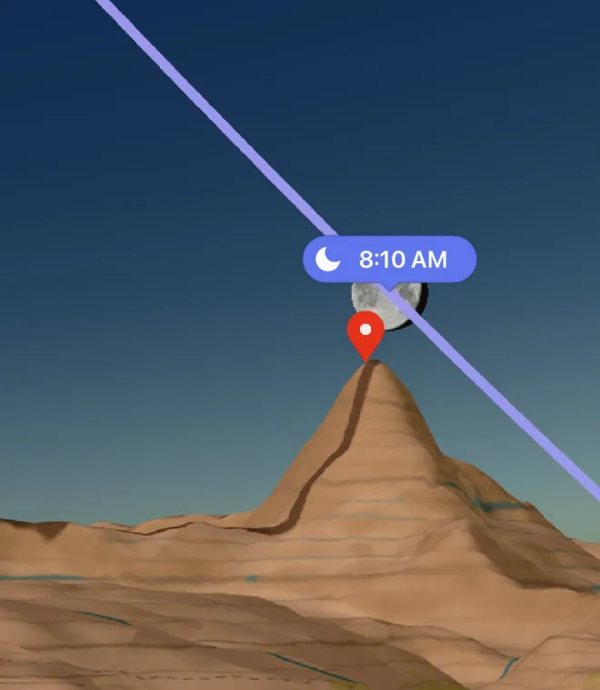
The Lens sheet
In Observer View, the toolbar's Camera button becomes Lens.
- FacingThe direction you look, 0–360°.
- Look UpTilt your view up to 80° or down to −80°.
- Focal Length14–600 mm, as on a full-frame camera, with quick picks at 24, 50, 85, 200 and 400 mm.
- Eye HeightUp to 1000 m above where you stand.
- Face SubjectTurns you back to the marker, at standing height.
- Reset LookBack to the view as it opened.
The observer pin
- Move itDrag the pin, or touch and hold the map where you want it.
- Tap itSee how far it is from the marker, look from there, or remove it.
- DirectionsThe bar at the bottom of the view shows the distance and opens directions to the pin in your maps app.
- Kept with your placesEach saved location keeps its own pin, and a plan link shared from the view opens right in it.
MacClick the eye in the toolbar, or press ⌥⌘O. Click where you'll stand to place the pin.
The sky around you
AR Sky View
Hold up your phone to see the sun's and moon's paths across the real sky, hour by hour, from where you're standing.
MacAR Sky View needs a camera you can hold up to the sky, so it's on iPhone, iPad and Android. The 3D Compass below works on the Mac too.
- 1The sun's pathA dot and a time at every hour.
- 2The sun nowOr at the time you pick on the timeline.
- 3The moon's pathWith its hours, in blue.
- 4Compass accuracyHeading, tilt and how far off the compass may be. Smaller is better.
- 5Orientation arrowsPoint the way to a sun or moon that's off screen.
- Now, or any timeIt follows the clock. Drag the timeline to see another hour; return to now and it follows the clock again.
- Where you areIt uses your own location and leaves the map's place and time as they were.
- Show Milky Way PROIn AR settings: the galactic core's path across tonight's sky.
If the paths look off
Phone compasses drift near cars, rails and metal. Move the phone in a figure-8 until the paths settle. For a precise fix, with the sun or moon in view: in AR the toolbar's Camera button becomes Calibrate. Tap it, start the calibration, centre the real sun or moon in the crosshair and tap Calibrate.
AndroidCalibration lines up on the sun when it's up, otherwise on the moon.
3D Compass
From the menu, 3D Compass draws the day's sun and moon paths (and the Milky Way's core) on a dome over a compass. Drag it, or use Time of Day, Tilt and Heading, to see where everything stands at any hour.
Light and shade
Shadow Map PRO
Buildings and terrain cast real shadows from the sun at the selected time. Drag the timeline and watch them swing round.
- 1Shadow objectA box at the marker, standing in for a person, a tree or a building you're planning.
- 2Object HeightSet its height and width in the Shadow Map's settings.
- 3Shadow LengthHow far its shadow reaches at the selected time, from its height and the sun's.
- 4The sunAt the selected time. Below the horizon there are no shadows, just the night's blue light.
- Open itQuick Actions › Shadow Map, or from the menu.
- Drag the timeThe shadows move with the sun.
- Tap the mapMoves the marker and its object.
iPhone · iPadIn the Shadow Map, Rise & Set shows the Shadow Ratio and the Shadow Length.
On iPhone Duo, opened out and turned sideways, Split View shows the Shadow Map beside the main map.
Plan ahead
Clouds, the night sky, the moon, and reminders so you don't miss it.
The sky
Cloud cover and rain PRO
The forecast, drawn on the map and tied to the timeline. Find a clear night for the stars, or a few high clouds to catch the sunset.
- Go flatWeather layers draw on Satellite 2D and Terrain 2D.
- Tap LayersThe button under 2D/3D. Choose Cloud Cover or Precipitation.
- Drag the timeThe forecast steps hour by hour, about five days ahead.
Night sky
Milky Way Planner
A great Milky Way night needs three things at once: real darkness, the galactic core above the horizon, and the moon out of the way. The planner finds where they overlap.
Darkness 1
Core up 2
Moon up 3
- 1Dark windowAstronomical night: the sun at least 18° below the horizon.
- 2The coreWhen the galactic core rises, peaks and sets, with the direction to face.
- 3MoonlightHow bright the moon is, and whether it's up during the dark.
- 4Shoot windowDark, with the core up, and, if the moon is half lit or more, with the moon down.
What makes the score
- How long the real darkness lasts (best at 6 hours or more)
- How high the core climbs (best at 50° or higher)
- How little moonlight there is
Best Milky Way Nights
View best nights ranks the next 30 nights at your location, with when and where the core peaks. Tap one to plan it. The first three are free; PRO shows them all.
- Great Milky Way Nights PROIn Alerts: a heads-up one to three days before a great night at any of your saved locations.
- Milky Way widgetTonight's rating, dark window and core peak on your Home Screen.
- Show Milky WayIn AR Sky View, see where the core will cross tonight's real sky.
The month ahead
Moon Calendar
Every day's moon at a glance, month after month. Tap a day for its full story.
August 2026
28 August 2026
Visible at your location
Plus golden hour, blue hour and every stage of twilight.
Sun & Twilight, decoded
Each twilight has a dawn and a dusk
Without opening the app
Alerts, widgets and Siri
Let LightPlan tell you when the light is coming.
Alerts
Open Alerts from the menu, pick an event, then choose When: at the moment it happens, or from 5 minutes to a day before. Choosing a time turns the alert on; None turns it off. Alerts follow where your phone is.
Free alerts repeat every day. With PRO, Repeat picks the days of the week.
Widgets
Countdowns to the next sunrise, sunset, moonrise or moonset, golden hour, the moon, the Milky Way and a month of moon phases, for the Home Screen and, on iPhone, the Lock Screen. Add them from your Home Screen's widget gallery.
iPhone · iPadHome Screen widgets are free to try for 14 days, then part of PRO.
Ask Siri
“When is golden hour in LightPlan”
“When is sunset in LightPlan”
“What is the moon phase in LightPlan”
Siri answers for where you are, or for a saved location by name. You'll find the same actions in the Shortcuts app.
Keep and share
Your places, and plan links for friends.
Your spots
Saved locations
Save the places you shoot, and each one comes back exactly as you left it: the view, the zoom and the observer pin.
- Save a spotTap + at the top, name it and pick a folder (or make a new one). The marker's spot and the current view are saved.
- Open oneTap the arrow at the top right, then a location. Current Location takes you to where you are.
- Swipe left on a locationTo edit, move it to another folder, share or delete it. Touch and hold to reorder.
- AndroidEdit the listIn edit mode, each location's menu renames it, moves it to a folder, shares or deletes it.
- Its own observer pinPlace a pin for Observer View once; it's there whenever you come back.
Free plans keep up to 5 locations; PRO keeps as many as you like.
Search by name or coordinates
Type a place in Search places, or paste coordinates in either form:
37.7749, -122.4194
37° 46' 29.6" N, 122° 25' 9.9" W
Decimal degrees use minus for south and west. Degrees, minutes and seconds need N, S, E or W.
Big screen
LightPlan on Mac
The whole planner side by side: your places, the map and every control, with your saved locations synced from iPhone.
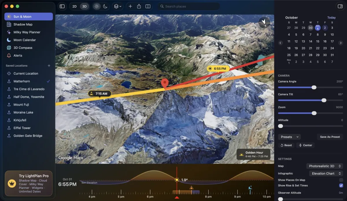 1
2
3
4
5
6
1
2
3
4
5
6
- 1SidebarSun & Moon, Shadow Map, Milky Way Planner, Moon Calendar, 3D Compass and Alerts.
- 2Saved LocationsBy folder. Right-click one to edit, share a plan link, or delete it.
- 3ToolbarSearch, Add, the map, 2D | 3D, Sun | Moon, Layers, Observer View, Settings and Share.
- 4MapClick to move the marker. Scroll or pinch to zoom.
- 5TimelineScroll over it to change the time; a trackpad flick keeps it gliding.
- 6InspectorThe date, the Camera (or Lens) controls and Rise & Set, and day details from the planners.
- Observer View⌥ ⌘ O
- Zoom the mapScroll · Pinch
- Change the timeScroll over the timeline
- Help, What's New, Contact SupportHelp menu
Good to know
What's free, what's Pro, and quick answers.
Plans
Free and Pro
LightPlan is free to use, every day. LightPlan Pro opens every date and the tools for serious planning, and starts with a free trial.
| Free | PRO | |
|---|---|---|
| Sun and moon lines, times, timeline, golden and blue hour | ✓ | ✓ |
| Dates | Today and the next 2 days | Any date |
| Saved Locations | 5 | Unlimited |
| Photorealistic 3D, Terrain and 2D maps, camera presets | ✓ | ✓ |
| Observer View | — | ✓ |
| Shadow Map | — | ✓ |
| Cloud cover and rain | — | ✓ |
| AR Sky View, 3D Compass, Moon Calendar | ✓ | ✓ |
| Milky Way Planner | Any free date, and the 3 best nights | The 30-night forecast, alerts, and the core in AR |
| Alerts | Sunrise and sunset | Every event, on the days you choose |
| Widgets | 14-day trial on the Home Screen | ✓ |
| Share plans | ✓ | ✓ |
To start, tap the LightPlan Pro card at the bottom of the menu, or any PRO badge.
Answers
Questions
Why can't I see the eye button for Observer View?
It's on the 3D maps only: Photorealistic 3D and Terrain 3D. On a flat map, tap 2D / 3D first.
Why won't cloud cover turn on?
Weather layers draw on the flat maps. Switch to Satellite 2D or Terrain 2D; if you pick a layer on a 3D map, LightPlan offers to switch for you. The forecast reaches about five days ahead.
Which time zone are the times in?
The location's own. Plan a sunrise in Iceland from Japan and you'll see Iceland's clock time, just as you'll live it there.
Why is the red line faint?
The sun or moon you're tracking is below the horizon at the selected time. The line still points to it, so you can see where it will come up.
My times are a little different from another app's. Why?
Apps treat the horizon and the air's bending of light differently. LightPlan's sun and moon are tested against the U.S. Naval Observatory and NASA JPL. If you're up high, raise Marker Distance From Ground in Settings: from a height the horizon drops, so the sun rises earlier and sets later.
What's the difference between the marker and the observer pin?
The red marker is what you're photographing; every line starts there. The blue observer pin is where you'll stand, for Observer View. You can use the marker alone.
How do I get back to the current time?
Tap Reset in the toolbar. Double-tapping the timeline does it too.
Does a plan link stop working?
Links are kept for a year after the plan's date.
Why does it say the sun doesn't rise (or set)?
Near the poles there are days when the sun or moon stays up, or down, all day. LightPlan shows those days as they are.
How do I see the tips again?
Tap Product Tour at the top of this Help screen, and the tips play again on the real controls.