LightPlan shows architecture and real estate photographers where the light will fall on a building before they get there. See which facade the sun reaches and when, where neighbouring buildings and trees cast their shadows, and when blue hour starts for twilight exteriors, all on Google's photorealistic 3D city. Then frame the shot from the street, a rooftop or a drone, and send the plan to your client.
Why architectural and real estate photographers use LightPlan
Know which side gets the sun
Sun lines drawn over Google's photorealistic 3D buildings show where the sun rises, sets and stands at any time, so you know which facade is lit before you book the shoot.
See the shadows on site
Shadow Map shows where buildings, trees and terrain cast shadows at any hour, so you can avoid a neighbour's shadow across the entrance (Pro).
Twilight exteriors, timed
Blue hour and golden hour to the minute, for the property's own location and time zone, with alerts and Add to Calendar.
Street, roof or drone
Observer View frames the building from where you'll stand, with a 14–600 mm lens, and eye height up to 1000 m for rooftops and drones (Pro).
Send the plan to your client
One link with the place, time and view. Agents and property managers see it on a 3D map on the web, with directions, without installing anything.
Plan at your desk
A native Mac app with your saved properties synced from iPhone and iPad, and cloud cover on the map before you commit to a date.
When does the front of the building get the sun?
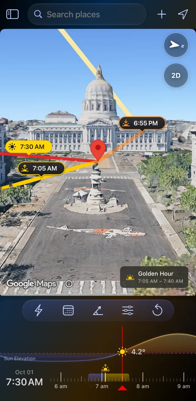
It's the first question on any architecture or property shoot, and LightPlan answers it from your desk. Here's San Francisco City Hall from Civic Center Plaza on the morning of 1 October.
- Search for the address and put the marker on the building.
- Switch to Photorealistic 3D: you see the real building, its neighbours and the trees.
- Drag the timeline. The lines point to the sunrise, the sunset and the sun at the time you pick, so you can watch it swing round onto the facade.
- Change the date to see how the light shifts with the season, or to plan a shoot months ahead.
In the capture, the sunrise and 7:30 AM lines run back across the plaza toward the camera: the morning sun is behind you, on the front of the building and the dome. Golden hour that morning runs from 7:05 to 7:40 AM, and the chip on the map says so.
Shadow Map: see where the light falls
Drag the timeline and every building, tree and hillside casts its real shadow at that moment. Here is San Francisco City Hall on the same day, six and a half hours apart:
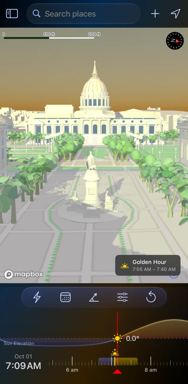
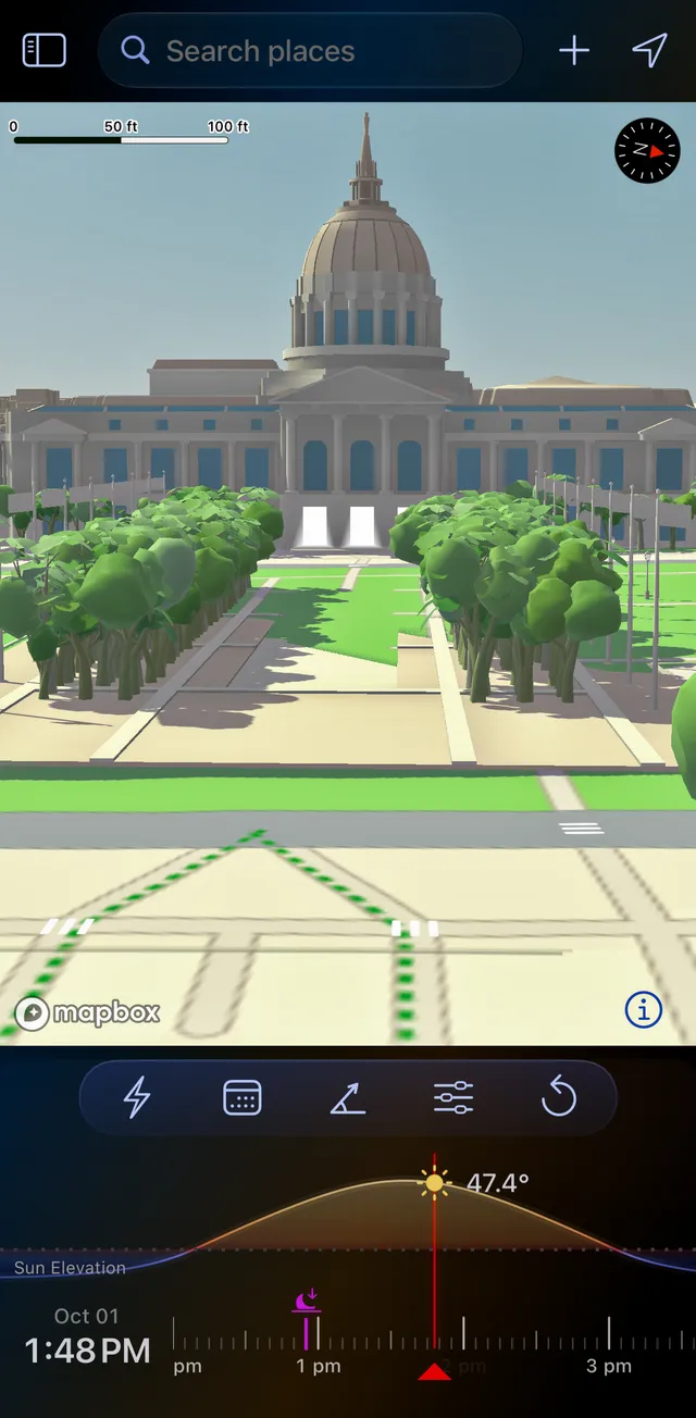
San Francisco City Hall, 1 October 2026.
- Find open shade for a portrait session, or the hour a facade is evenly lit with no hard shadows across it.
- Measure a shadow. A shadow object at the marker stands in for a person, a tree or a building; set its height and width, and LightPlan shows its Shadow Length and Shadow Ratio. At 1:48 PM here, a 6 ft person casts a shadow about 5.5 ft long.
- On iPhone Duo: Opened out and turned sideways, Split View shows the Shadow Map beside the main map.
- Beyond photography: when a garden, terrace or street gets sun, or where a new building's shadow will fall.
For architecture and real estate, Shadow Map answers the questions clients ask: when the entrance is out of a neighbour's shadow, when the terrace or pool gets sun, and when the street is evenly lit for a clean exterior. You can check any date and time before you go. Shadow Map is part of LightPlan Pro; open it from Quick Actions or the menu.
Twilight exteriors, timed to the minute
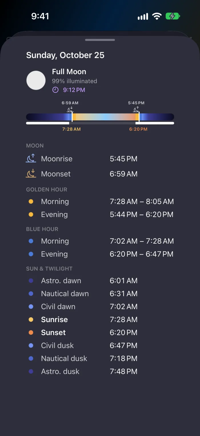
Twilight exteriors are shot in blue hour, when the sky's brightness balances the building's interior and exterior lights. The window is short, so the timing matters.
- Blue hour to the minute. LightPlan times it by the sun's angle (4° to 6° below the horizon), so it's right for the season and the latitude. In this capture, the evening blue hour runs from 6:20 to 6:47 PM.
- In the property's time zone. Times are always local to the place on the map, even when you plan a shoot in another city.
- Every stage of twilight, from civil to astronomical, with dawn and dusk times for each.
- Add to Calendar or set an alert, so you're set up before the light arrives.
Frame it from the street, a roof or a drone
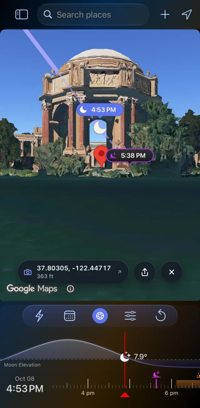
Observer View puts you where you'll set up, at eye level on the photorealistic 3D city, so you can see the composition before you arrive (Pro).
- Your lens: set a focal length from 14 to 600 mm (full-frame), from a wide establishing shot to a compressed detail.
- Your height: standing height by default, or up to 1000 m to preview a rooftop, a balcony or a drone position.
- Your line of sight: it turns red where the land blocks the view, so you know a ridge or a slope won't get in the way.
- The sun or moon in the frame: its path is drawn across the real skyline, for a sun star off a corner or a moon over the roofline.
Send the plan to your client
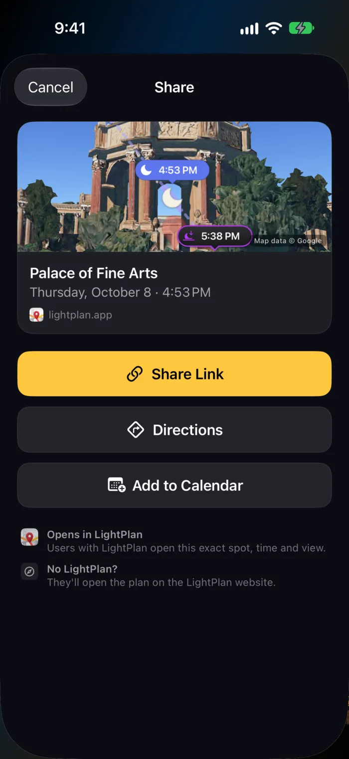
Architecture and property shoots involve other people: the agent who books the slot, the property manager who unlocks the doors, the second shooter or drone pilot. LightPlan's Share Link sends the exact place, time and view as one short link.
- They don't need the app. The link opens on the web on a 3D map, with the day's light windows and directions.
- With LightPlan, it opens at the same spot, time and camera angle, or straight into Observer View.
- Add to Calendar puts the shoot time, or the day's golden and blue hours, in your calendar; Directions opens your maps app to where you'll stand.
Sharing is free.
Easy from the first minute
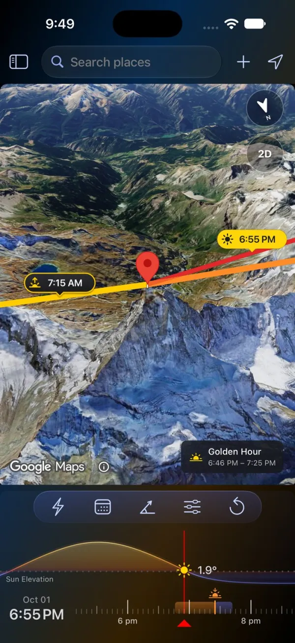
LightPlan is built so you can plan a shot without a tutorial. Your first plan takes three steps:
- Put the marker on your subject. Search for a place, or tap the map.
- Pick the day and time. Tap Date, then drag the timeline to the hour.
- Read the light. The lines point to the sun and moon, and a chip on the map says when it's golden or blue hour.
There are no panels to decode before you start. Times are always in the place's own time zone, the timeline is coloured like the light, and Product Tour replays the tips on the real controls whenever you want a refresher.
That matters on a working shoot: an assistant or second shooter can pick it up in minutes, and so can a client you show it to.
What's free, and what's Pro
LightPlan is free to use every day: sun and moon lines over Photorealistic 3D buildings, golden and blue hour, AR Sky View, plan links and 5 saved locations, for today and the next 2 days. LightPlan Pro ($2.99 a month or $19.99 a year in the US, with a free trial) adds any date, unlimited saved properties, Shadow Map, Observer View, weather layers and every alert. See everything in Free and Pro.
Frequently asked questions
What's the best app for architecture and real estate photographers to plan the sun?
LightPlan is built for it. It draws the sun's direction at any time over Google's photorealistic 3D buildings, so you can see which facade is lit before you book the shoot; Shadow Map shows where buildings, trees and terrain cast shadows; it times golden hour and blue hour for twilight exteriors; Observer View frames the building from where you'll stand, with your focal length; and plan links send the shoot to a client or agent who doesn't have the app. It's free to start on iPhone, iPad, Mac and Android.
How do I know when the sun will hit the front of a building?
Put LightPlan's marker on the building, switch to the Photorealistic 3D map and drag the timeline. The lines point to where the sun rises, sets and stands at the selected time, drawn over the real buildings, so you can see when the sun swings round onto the facade you need. Change the date to plan a shoot weeks or months ahead (any date is part of Pro).
When should I shoot twilight exteriors?
Most twilight exteriors are shot in blue hour, when the sky's brightness balances the building's interior and exterior lights. LightPlan times blue hour by the sun's angle (from 4° to 6° below the horizon), for the property's own location and time zone, so you know the window to the minute. You can add it to your calendar or set an alert.
Can I see where a building's shadows will fall on a future date?
Yes. LightPlan's Shadow Map draws the shadows from buildings, trees and terrain at the selected time, and they move as you drag the timeline. A shadow object at the marker shows how far a building, tree or person's shadow reaches. Shadow Map is part of LightPlan Pro ($2.99 a month or $19.99 a year in the US), which starts with a free trial.
Can I plan drone and rooftop shots of a property?
Yes. In Observer View you can raise your eye height up to 1000 m to preview the view from a rooftop, a balcony or a drone, with your focal length, and see the sun or moon against the skyline. Check local drone rules separately.
Can I share the shoot plan with my client or agent?
Yes. Share Link sends the exact place, time and view as one short link. People with LightPlan open it in the app; anyone else sees it on the web on a 3D map with the day's light windows and directions. Add to Calendar adds the shoot time, or the day's golden and blue hours.
Is LightPlan free?
LightPlan is free to use every day with no account. The free version covers today and the next 2 days: sun and moon lines and times, golden and blue hour, Photorealistic 3D, Terrain and 2D maps, AR Sky View, the 3D Compass, the Moon Calendar, the Milky Way Planner with the 3 best nights ahead, 5 saved locations, sunrise and sunset alerts, and plan links. LightPlan Pro ($2.99 a month or $19.99 a year in the US, with a free trial) adds any date, unlimited locations, Observer View, Shadow Map, weather layers, the full Milky Way forecast, every alert and widgets.
Try LightPlan free
Plan your next property shoot in 3D. Free to start on iPhone, iPad, Mac and Android.